


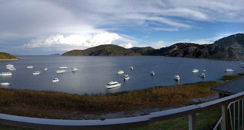
Lake Titicaca Facts: Where It Is, How High, What It Means
Lake Titicaca lies on the Peru and Bolivia border at 3,812 m (12,507 ft). It covers 8,372 km² (3,232 sq mi) and is up to 281 m (922 ft) deep. Puno is the main town on the Peruvian shore and Copacabana on the Bolivian shore.

In this guide
Short answer: Lake Titicaca lies high in the Andes on the border between Peru and Bolivia, at 3,812 m (12,507 ft) above sea level. It covers 8,372 km² (3,232 sq mi) and is up to 281 m (922 ft) deep. The western side belongs to Peru's Puno Region and the eastern side to Bolivia's La Paz Department.
Where Lake Titicaca is located
Lake Titicaca sits on the altiplano, the high plateau between the two main ranges of the Andes, about 390 km (240 mi) by road southeast of Cusco and about 70 km (45 mi) in a straight line northwest of La Paz. Puno is the main town on the Peruvian shore. Copacabana is the main town on the Bolivian shore.
On a map of South America, look for the point where Peru, Bolivia and the top of Chile almost meet. The lake is the large blue shape just north of that point, shaped roughly like a puma leaping to the northwest, with a much smaller lake hanging off its southeastern corner. The two parts are the Lago Grande (also called Lago Chucuito) and the shallower Wiñaymarka, joined by the Strait of Tiquina, which narrows to about 800 m (half a mile).
Most visitors reach the lake from Cusco and stay in Puno. From there the Uros reed islands are a short boat ride across the bay, and the farther islands of Taquile and Amantaní take a few hours by boat. The Bolivian side, with Copacabana and the Isla del Sol, is a day's drive along the southern shore.
Lake Titicaca in numbers
Lake Titicaca is about 190 km (118 mi) long and 80 km (50 mi) wide, with an average depth of 107 m (351 ft) and a volume of about 896 km³ (215 cu mi) of fresh water. The table under this paragraph lists the figures with their sources. Treat the measurements as approximate: the level of the lake rises and falls with the rainy and dry years, and the shoreline moves with it.
A few of those numbers explain what you feel on a visit. The water stays between about 10 and 14°C (50 and 57°F) all year, which is why nobody swims for long. Five main rivers feed the lake, but only about 10% of the water leaves through its one outlet, the Desaguadero River, toward Bolivia. The other 90% evaporates under the altiplano sun. That strong sun at 3,812 m is also what burns you on a boat deck in under an hour, even on a cold day.
Is it the highest navigable lake in the world?
Lake Titicaca is often called the highest navigable lake in the world, and it is the claim you will hear on every boat. It holds up if you mean a large lake with regular passenger and cargo boats. Smaller lakes at greater heights exist in the Andes and the Himalaya, and some have small boats on them. We repeat the claim with that footnote.
Protected waters
Part of the Peruvian side is a protected area. The Reserva Nacional del Titicaca was created in 1978 and covers 36,180 hectares (about 89,400 acres) in two sectors, around Puno Bay and near the Ramis River, mostly totora reed beds. SERNANP, Peru's protected areas service, runs it. The lake is also a Ramsar wetland of international importance, listed by Peru in 1997 and Bolivia in 1998.
Is Lake Titicaca in Peru or Bolivia?
Lake Titicaca is in both. The border runs through the water from north to south, with Peru on the western side and Bolivia on the eastern side, including most of the Wiñaymarka basin. The best-known islands split between the two: the Uros, Taquile and Amantaní are in Peru, and the Isla del Sol and Isla de la Luna are in Bolivia.
The two shores feel different. Puno is a working Peruvian city of hotels, a busy port and markets. Copacabana is a small pilgrimage town around a white Moorish-style basilica, with a beach of boats and trout grills. Crossing between them takes about three hours by road through the Kasani border post, or longer through Desaguadero. US citizens need no tourist visa for Bolivia since December 1, 2025. Read our Bolivia guide for US travelers before you cross.
What the name Titicaca means
Nobody knows for certain what Titicaca means, and you should be wary of anyone who tells you otherwise. The most repeated translation is "rock of the puma" (or "gray puma"), from words in Aymara and Quechua, and guides often add that the lake's outline looks like a puma chasing a rabbit. Another theory traces the name to a sacred rock on the Isla del Sol, recorded in 15th and 16th century sources as something close to "thakhsi cala". Before the Spanish arrived, the lake itself may have had other names.
How to say it: tee-tee-KAH-kah, with the stress on the third syllable. Americans tend to laugh at the name the first time. Peruvians have heard the joke.
The peoples of the lake
Two peoples live around Lake Titicaca: Quechua speakers, mostly on the northern and western shores and on the islands of Taquile and Amantaní, and Aymara speakers, mostly on the southern shore and the Bolivian side. Both farm the terraced hills, fish, keep animals and speak Spanish as a second language.
The families of the Uros islands identify as Uros and speak Aymara today. Their older language has disappeared. The Capachica peninsula, where Llachón is, speaks Quechua. Towns like Chucuito, Juli and Pomata on the road to Bolivia speak Aymara, and many still celebrate their fiestas with dances you will not see in Cusco.
Puno's biggest event is the Fiesta de la Virgen de la Candelaria every February, when thousands of dancers fill the city. UNESCO added it to its list of intangible cultural heritage in 2014. If you travel in early February, book Puno hotels months ahead or avoid those dates.
When you visit communities, you are a guest in someone's home and workplace. Ask before photographing people, buy directly from the person who made the textile, and accept that a homestay means the family's rules and the family's food. Our guide to who the Aymara are goes further.
The islands worth visiting
The five island visits that matter are the Uros reed islands, Taquile, Amantaní, and, on the Bolivian side, the Isla del Sol from Copacabana. Each one answers a different question, so choose by what you want to see, not by how many you can fit.
Uros floating islands
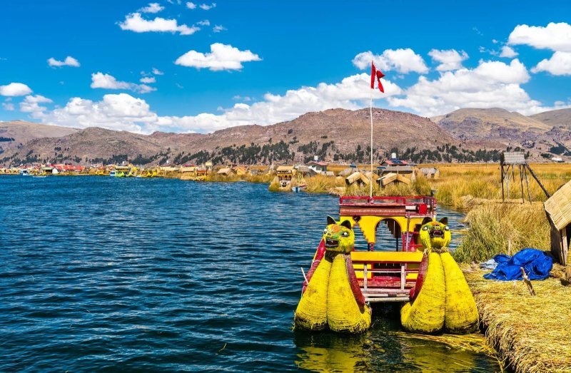
The Uros are artificial islands built from layers of totora reed in the bay of Puno, about 30 minutes by boat from the pier. Families live on them, add fresh reeds on top as the lower layers rot, and show visitors how the islands are anchored and rebuilt. The number of islands changes as families split and join, and is usually given as 60 to 90. The visit is short and touristy, and still worth an hour. Our Uros floating islands guide explains how they are made and how to visit fairly.
Taquile
Taquile is a hilly Quechua-speaking island about three hours by boat from Puno, known for its textiles. UNESCO proclaimed Taquile and its textile art a masterpiece of intangible heritage in 2005 and inscribed it on its Representative List in 2008. Men knit the chullo hats and both men and women weave, on looms that go back to before the Inca. A day trip means a walk across the island on stone paths, lunch with lake views and a steep descent to the boat.
Amantaní
Amantaní is a larger, quieter Quechua-speaking island where most visitors stay overnight with a family. Two hills rise above the farms, each with a ceremonial site: Pachatata (Father Earth) and Pachamama (Mother Earth). The climb to Pachatata reaches about 4,130 m (13,550 ft), and sunset from the top is the reason to go. Nights are cold and the houses have no heating. Bring a warm layer to sleep in.
Copacabana and Isla del Sol, Bolivia
Copacabana is the Bolivian lakeside town where boats leave for the Isla del Sol. In Inca belief, the Sun and the first Inca rulers came out of the lake here, and the island has Inca-era ruins, terraces and long stone stairways. Access to parts of the island has been closed at times because of disputes between its communities, so confirm which landing is open before you go. Our guide to Copacabana and the Isla del Sol covers the boats and the walking routes.
On the shore
Two shore stops are worth a half day from Puno: the funerary towers (chullpas) of Sillustani on Lake Umayo, a separate lake about 45 minutes away, and the colonial churches of the Aymara towns on the road to Bolivia, from Chucuito to Juli.
Best time to visit Lake Titicaca
The best time to visit Lake Titicaca is May to October, the dry season, when the sky is clear and the boats run on calm water. Days are bright and mild in the sun. Nights from June to August drop well below freezing in Puno, so pick a hotel that has heating. December to March brings afternoon rain and fewer visitors, and early February brings the Candelaria festival. Every month works for a visit. You trade sunshine for crowds, not access.
How to get to Lake Titicaca from Cusco
Most people go from Cusco to Puno by road, in about ten hours on a daytime tourist bus with stops, or in about seven hours on a regular bus. Flying means going to Juliaca, the closest airport, about an hour by road from Puno. The PeruRail Titicaca train runs between Cusco and Puno on set days only.
Here is how the options compare in practice:
- Route of the Sun tourist bus. A full day with a guide and stops at the Andahuaylillas church, the Raqchi temple, the La Raya pass at 4,335 m (14,222 ft) and the Pukara museum. Our pick if you have the day.
- Regular day or night bus. The cheapest and fastest by road. The night bus saves a hotel night and costs you a night's sleep before a boat day.
- PeruRail Titicaca train. About ten and a half hours with meals, an observation car and a stop at La Raya. It runs a few days a week and PeruRail posts service notices, so check perurail.com before you plan around it.
- Flight to Juliaca. Inca Manco Cápac airport has regular flights from Lima. Direct flights from Cusco have come and gone over the years, so check the airlines for your dates.
Altitude matters more than the mode of transport. Puno sits about 430 m (1,400 ft) higher than Cusco, so do the lake after Cusco, not before. Our guide on how to get from Cusco to Lake Titicaca compares the options in detail.
Seeing the lake on a tour
All our Lake Titicaca tours start from Puno or reach it overland from Cusco. The Lake Titicaca tours from Puno and Cusco page compares the day routes and the multi-day trips that include the lake. If you want the lake as part of a longer trip, our two weeks in Peru with two nights on Lake Titicaca climbs from the coast through Arequipa and the Colca Canyon to Puno before Cusco and Machu Picchu.
| Fact | Value | Source |
|---|---|---|
| Location | Peru (Puno Region, west) and Bolivia (La Paz Department, east) | en.wikipedia.org |
| Surface altitude | 3,812 m (12,507 ft) | en.wikipedia.org |
| Area | 8,372 km² (3,232 sq mi) | en.wikipedia.org |
| Length and width | 190 km by 80 km (118 by 50 mi) | en.wikipedia.org |
| Maximum depth | 281 m (922 ft) | en.wikipedia.org |
| Average depth | 107 m (351 ft) | en.wikipedia.org |
| Volume | about 896 km³ (215 cu mi) | en.wikipedia.org |
| Water temperature | 10 to 14°C (50 to 57°F) | en.wikipedia.org |
| Outlet | Desaguadero River, about 10% of the outflow (90% evaporates) | en.wikipedia.org |
| Protected area (Peru) | Reserva Nacional del Titicaca, 1978, 36,180 ha | gob.pe |
| Ramsar wetland | Peru 1997, Bolivia 1998 | en.wikipedia.org |
| Main town in Peru | Puno, about 3,830 m (12,560 ft) |
Sources
Questions people ask
Where is Lake Titicaca?
Lake Titicaca is on the border of Peru and Bolivia, on the high Andean plateau called the altiplano, at 3,812 m (12,507 ft). Puno is the main town on the Peruvian side, about 390 km (240 mi) by road from Cusco. Copacabana is the main town on the Bolivian side, about three hours from Puno.
Is Lake Titicaca in Peru or Bolivia?
Both. The border crosses the lake from north to south. The western side, with Puno and the Uros, Taquile and Amantaní islands, is in Peru's Puno Region. The eastern side, with Copacabana and the Isla del Sol, is in Bolivia's La Paz Department. You can visit both shores on one trip.
How high is Lake Titicaca?
The lake surface is at 3,812 m (12,507 ft), higher than Cusco at 3,400 m (11,150 ft). Puno town sits a little above the shore at about 3,830 m (12,560 ft). Expect shortness of breath on stairs and cold nights, and arrive after a few days in Cusco rather than straight from sea level.
What does Titicaca mean?
The meaning is uncertain. The most common translation is "rock of the puma", from Aymara and Quechua words. Another theory links the name to a sacred rock on the Isla del Sol recorded in colonial sources. Treat any single translation you hear as a popular explanation, not a settled fact.
How deep is Lake Titicaca?
Lake Titicaca reaches 281 m (922 ft) at its deepest point, in the large northern basin, and averages about 107 m (351 ft). The smaller southern basin, Wiñaymarka, is much shallower. The water stays around 10 to 14°C (50 to 57°F) all year.
Can you swim in Lake Titicaca?
You can, but few people stay in long. The water is about 10 to 14°C (50 to 57°F), the air is thin and the sun is strong. Avoid swimming near Puno, where the bay receives the city's wastewater. A quick dip off a beach on Taquile or Amantaní on a sunny afternoon is the usual way.
How many days do you need at Lake Titicaca?
Two days is the right amount for most visitors: one for the Uros and Taquile, one for Amantaní, Sillustani or the road to Bolivia. One day covers the Uros and Taquile only. Add a third if you want a night with a family on Amantaní and time in Copacabana.
This guide was last reviewed in October 2026. Prices, rules and timetables are quoted with the date we checked them.