


Rainbow Mountain Altitude, Weather and How to Get There
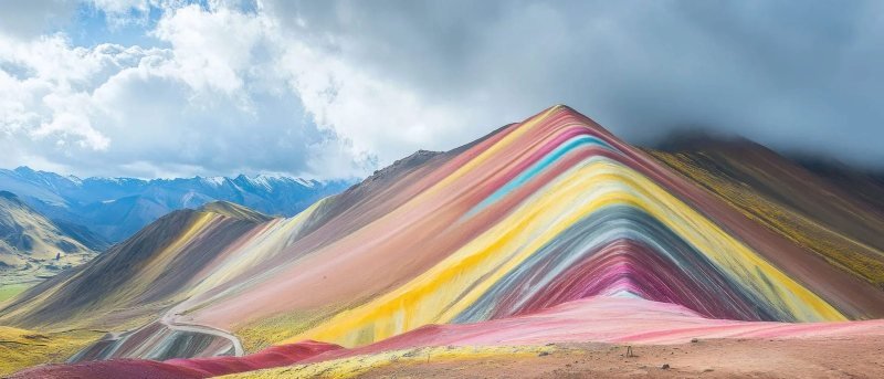
Rainbow Mountain (Vinicunca) stands at 16,522 ft (5,036 m) at the viewpoint most tours reach, about 100 km (62 mi) and three hours by road southeast of Cusco. The walk up from the trailhead takes 90 minutes to two hours. The stripes are mineral layers, and the dry months of April to October show them best.

In this guide
Short answer: Rainbow Mountain, called Vinicunca in Quechua, stands at 16,522 ft (5,036 m) at the viewpoint most tours reach, according to Peru's official tourism inventory. It is about 100 km (62 mi) and three hours by road southeast of Cusco. From the trailhead at about 15,092 ft (4,600 m) the walk takes 90 minutes to two hours uphill. The colors are mineral layers in the rock, and they show best in the dry months, April to October.
The real altitude of Rainbow Mountain
The viewpoint at Vinicunca sits at 16,522 ft (5,036 m), the altitude recorded for the mountain in the inventory of tourism resources kept by Peru's trade and tourism ministry (MINCETUR). That is higher than any summit in the lower 48 states. Mount Whitney in California, the highest, reaches 14,505 ft (4,421 m), and you will stand about 2,000 ft (600 m) above it before lunch.
You will also see 5,200 m (17,060 ft) quoted all over the internet. Both numbers describe the same place. The ridge keeps rising above the viewpoint, and the inventory record for the Pitumarca side notes that the upper part of the hill passes 5,200 m. Tours stop at the viewpoint, so 16,522 ft (5,036 m) is the height you reach and the one we print on every page of this site.
The number that matters more is the trailhead. The vans drop you at about 15,092 ft (4,600 m) above the community of Chillihuani, which is already higher than almost every road in North America. From there the path gains roughly 1,400 ft (430 m) over about 1.9 mi (3 km) one way. At that height each breath delivers roughly half the oxygen you get at sea level. The walk is short. The air is what makes it hard.
On the map, Vinicunca sits on the boundary of the Cusipata and Pitumarca districts in the Cusco region, in the range of Ausangate, the glaciated peak at 20,945 ft (6,384 m) that fills the view from the ridge on a clear morning.
Why the colors
The stripes are layers of sedimentary rock that formed flat on an ancient sea floor and lake beds, then tilted on edge when the Andes rose. Each band is a different mineral mix, and the inventory record lists them. Pink comes from red clay, mud and sand. White comes from quartz sandstone and lime-rich marl. Red comes from claystone rich in iron. Green comes from phyllite and clay rich in iron and magnesium. Brown comes from a conglomerate with magnesium. The mustard yellow comes from calcareous sandstone with sulfur minerals.
Nobody's grandparents hiked here, because the stripes were under ice. The ridge carried small glacier caps that melted away, reported as gone by 2013, and visitors started arriving in numbers in the middle of that decade. The colors look strongest when the rock is dry and the sun is high. A fresh snowfall in the rainy months covers them entirely, and the photos from those days show a white ridge with a few tired hikers in front of it.
Weather by month
The dry season runs from May to September in the Cusco highlands, with the rainy season from September to April and the heaviest rain from December to March, per Peru's weather service SENAMHI. The tourism inventory recommends April to October for Vinicunca. We agree, and we think May and June give the sharpest light.
| Months | Season | What the day is like | Our verdict |
|---|---|---|---|
| April to May | End of the rains, start of the dry season | Green valleys, frost at dawn, clear mornings, some afternoon cloud | Very good, fewer people than June to August |
| June to August | Dry season, peak | Hard frost at the trailhead, strong sun by 10 a.m., cold wind on the ridge, sharpest colors | Best light, most crowded ridge. Go on the earliest departure |
| September to October | Dry season ending | Milder dawns, clouds build earlier in the afternoon | Good, start early |
| November to March | Rainy season, heaviest December to March | Afternoon rain, hail and fresh snow on the ridge, muddy trail, stripes often hidden | Gamble. Palccoyo is the safer pick in these months |
Whatever the month, the day has the same shape. The trailhead is below freezing at dawn, with frost on the grass and ice on the puddles. The sun is strong by 10 a.m. and burns pale skin in under an hour. The wind on the ridge is cold even in full sunshine, and clouds build in the afternoon. The table under this section gives the pattern by period. The mistake people make is dressing for Cusco, a mild city at 11,150 ft (3,400 m). The ridge is a mile higher. Pack a warm jacket, hat and gloves for the first hour, a rain shell that blocks wind, and sunglasses and sunscreen for the rest.
The climb
The trail from the Llaqto sector of the Chillihuani community to the viewpoint measures about 1.9 mi (3 km) and takes about 1 hour 45 minutes on foot, per the inventory record. The first half follows a broad valley with a gentle grade. The last 20 minutes climb steep switchbacks to the ridge, and that is where most people stop every few steps to breathe. That pace is fine. Nobody is timing you.
Altitude illness is the real risk, and the advice below comes from the US CDC Yellow Book. The CDC puts any unacclimatized traveler at risk once sleeping altitude reaches 8,000 ft (2,450 m), and Cusco is far above that. Day trips that return to a lower altitude in the evening are much easier on the body than sleeping high, which is why Rainbow Mountain works as a day trip at all. Even so, sleep at least two nights in Cusco before you go. Read our guide to Cusco altitude and how to adjust before you book.
On the day, walk slower than feels natural, drink water at every stop, and eat the breakfast even if you are not hungry. A headache, nausea or dizziness that gets worse as you climb means you turn around with the guide and go down. The CDC lists acetazolamide as a preventive drug for travelers at medium or high risk, started the day before the ascent. It is prescription medicine with side effects, so the decision belongs to you and your doctor before the trip, not to a guide at the trailhead. Anyone with heart or lung disease should ask a doctor before booking. The descent takes about an hour on the same path, and loose gravel on the switchbacks is where people slip, so use poles if you brought them.
Horse option
Local families rent horses at the trailhead for the way up, paid in cash in soles to the owner who walks beside you. On our Vinicunca day tour the horse costs US$24 (S/80) per stretch via Cusipata or Pitumarca, and a motorbike ride is offered via Pitumarca at US$22 (S/70) per stretch (agency prices, as of October 2026). The horse carries you most of the way, and the last steep section to the ridge is on foot for everyone. Take the horse if you are over 65, if you landed in Cusco in the last two days, or if the first half of the walk leaves you dizzy. It is not cheating. Keep your gloves on, since the horse walks slowly in cold wind.
How to get to Rainbow Mountain from Cusco
There is no public transport to the trailhead, so almost everyone goes with a tour. The usual route leaves Cusco between 4:00 and 4:30 a.m., follows the paved highway south through Urcos for about two and a half hours to Cusipata for breakfast, then climbs a dirt road for about an hour to the trailhead. You are walking by 8 a.m., before the crowds and the clouds, and back in Cusco between 4 and 5 p.m. The second route goes through Pitumarca, a longer drive to a higher trailhead with a shorter, steeper walk.
Our Rainbow Mountain tour from Cusco runs the Cusipata route with a licensed guide, breakfast and lunch for US$137 per person. If you want the colors with far less climbing, the Palccoyo day hike reaches three striped hills on a near-flat ridge walk of about 20 minutes at 16,076 ft (4,900 m), for the same price. Our guide to which rainbow mountain to choose compares Vinicunca, Palccoyo and Pallay Punchu side by side. The Rainbow Mountain destination page lists every trip that includes it.
| Fact | Value | Source |
|---|---|---|
| Altitude at the viewpoint | 16,522 ft (5,036 m) | consultasenlinea.mincetur.gob.pe |
| Trailhead altitude | about 15,092 ft (4,600 m), Llaqto sector, Chillihuani community | |
| Walk | about 1.9 mi (3 km) one way, 1 hour 45 minutes up, about 1 hour down, 1,400 ft (430 m) of gain | consultasenlinea.mincetur.gob.pe |
| Distance from Cusco | about 100 km (62 mi), about 3 hours each way by road via Cusipata | |
| Location | Cusipata and Pitumarca districts, Cusco region, Ausangate range | en.wikipedia.org |
| Best season | April to October (dry season), per MINCETUR | consultasenlinea.mincetur.gob.pe |
| Opening hours at the site | 6:00 a.m. to 5:00 p.m. | consultasenlinea.mincetur.gob.pe |
| Horse to the last stretch | US$24 (S/80) per stretch, cash, paid to the owner (agency price, as of October 2026) | |
| Our day tour | US$137 per person, breakfast and lunch, licensed guide |
Sources
- MINCETUR, Inventario de Recursos Turísticos, Montaña Winikunka (Cusipata), altitude, trail and season
- MINCETUR, Inventario de Recursos Turísticos, Vinicunca (Pitumarca), upper ridge above 5,200 m
- Vinicunca, Wikipedia (mineral colors, glacier melt, districts)
- Ausangate, Wikipedia (elevation)
- SENAMHI, climate of the Cusco region (rainy and dry seasons)
- CDC Yellow Book, High Altitude Travel and Altitude Illness
- Mount Whitney, Wikipedia (elevation)
Questions people ask
How high is Rainbow Mountain?
The viewpoint at Rainbow Mountain (Vinicunca) is at 16,522 ft (5,036 m), per Peru's official tourism inventory. The ridge keeps rising above it and passes 5,200 m (17,060 ft), which is where the other number you see online comes from. The trailhead where the vans stop is at about 15,092 ft (4,600 m).
How far is Rainbow Mountain from Cusco?
About 100 km (62 mi) by road, or about three hours each way: two and a half hours on the paved highway south to Cusipata, then roughly an hour on a dirt road to the trailhead. Tours leave Cusco between 4:00 and 4:30 a.m. and get back between 4 and 5 p.m.
Why is Rainbow Mountain colorful?
The stripes are tilted layers of sedimentary rock, each with a different mineral mix: iron-rich clay for the red, quartz sandstone for the white, iron and magnesium minerals for the green, and sulfur-rich sandstone for the yellow. They were under small glaciers until the ice melted, reported as gone by 2013, which is why the mountain only became famous afterward.
What is the weather like at Rainbow Mountain?
Below freezing at dawn, hot sun by mid-morning, cold wind on the ridge and clouds in the afternoon, in every month. The dry season from May to September gives the clearest skies and the sharpest colors. From December to March, rain, hail and fresh snow often cover the stripes, so book an early departure or choose Palccoyo instead.
Is Rainbow Mountain hard to climb?
The walk is short, about 1.9 mi (3 km) each way with 1,400 ft (430 m) of gain, but it happens at 16,000 ft with roughly half the oxygen of sea level. Fit, acclimatized walkers take 90 minutes to two hours up and stop often on the last switchbacks. Sleep two nights in Cusco first, and take a horse if you are unsure.
Can you ride a horse up Rainbow Mountain?
Yes. Families from the local communities rent horses at the trailhead, and you pay the owner in cash in soles. On our tour a horse costs US$24 (S/80) per stretch (as of October 2026). The horse takes you most of the way, and the final steep section to the viewpoint is on foot for everyone.
Should I do Rainbow Mountain before or after Machu Picchu?
After. Machu Picchu sits at 7,970 ft (2,430 m), lower than Cusco, so it is the easy day. Rainbow Mountain is the highest point of most Peru trips. Put it at the end, after two or three nights in Cusco and the Machu Picchu days, when your body has had time to adjust.
This guide was last reviewed in October 2026. Prices, rules and timetables are quoted with the date we checked them.